
Census Bureau Data Helps Disaster Areas
The impending U.S. Census, or Census 2020, is very important for the City of Urbana. Many probably never realized that Census data could affect how the City responds to a disaster. It's true! The information we're given will help us to better serve you in an emergency or a disaster-situation, as well as secure federal funding for important programs and incentives for residents and stakeholders of Urbana. However, this data is only as good as the count that is taken during the Census. Briefly, you must be counted, you must be counted only once, and you must be counted where you live on April 1, 2020.
Central Illinois is Unique in its Climate Designation
Our weather can be unpredictable at times. Central Illinois averages around 50 days of thunderstorm activity a year which is above average for number of thunderstorm days for the United States. Central Illinois is vulnerable to tornadoes with an average of 54 occurring annually, which puts much of the state at around 9.7 tornadoes per 10,000 square miles annually. Central Illinois is on the border of two climate groups: hot-summer continental and humid sub-tropical, and this greatly affects local weather.
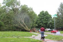
And our weather can change quickly. We saw evidence of this May 26, 2019 with the tornado that devastated residential areas in Southwest Urbana.
Disaster Can Happen at Any Time
How do recovery organizations, such as the Federal Emergency Management Agency, commmonly known as FEMA, or the Urbana first responders of the Public Works Department, the Police Department, the Fire Department, as well as Emergency Medical Technicians tailor their efforts to people's homes and businesses in affected areas?
They rely on the U. S. Census Bureau. Since October is National Emergency Care Month, this serves as a reminder for us to be ready. Part of this preparedness is to be accurately and completely counted during the Census that occurs every ten years in the United States. Once the data has been collected there are comprehensive tools that can help first responders with recovery efforts.
Programs supported by Census data provide key deomographic, socioeconomic and housing data that help guide not only recovery efforts but planning for potential future emergencies, as well.
So, where specifically can emergency management officials go to access this information?
The Census Bureau provids two key tools: OnTheMap for Emergency (OtM EM) and Census Business Builder: Regional Analyst Edition (CBB: RAE).
OnTheMap for Emergency Management is updated every four hours using feeds from the National Oceanic and Atmospheric Administration (NOAA) and other federal partners.
It overlays the boundaries of tropical storms, wildfires, floods, severe winter weather and other disaster declaration areas onto a map of key Census Bureau demographic and workforce data. It then aggregates the data to the event and allows officials to get updated information for potentially impacted areas.
Also, the information for each event is archived, allowing planners to compare information on previous events with ongoing emergencies. While OnTheMap for Emergency Management excels at providing detailed information for events as they occur, Census Business Builder allows emergency management officials to draw a “What if…” scenario for planning purposes.
Emergency planners prepare not only for the potential impact of weather events but also for other emergencies.
For example, many parts of Central Illinois are especially vulnerable to flooding and wind damage if tornados strike the area. Census Business Builder allows these planners to create maps of the ZIP codes along these frequently affected regions. These maps provide key data to help them plan evacuation routes, for example.
Another valuable data set is the Census Bureau’s LEHD Origin-Destination Employment Estimates (LODES). Knowing commuter flows – where people live and where they work – can help emergency responders and local officials plan evacuation routes and assess the potential extent of business damage caused by natural disasters.
Combining Census Bureau Data for a Full Picture
Many Census Bureau products combine demographic, socioeconomic and housing data with key business- and consumer-spending statistics. This information can help identify potential vulnerabilities. For example, it can tell planners if hospitals or building- materials wholesalers in potentially vulnerable areas are equipped and ready to handle an emergency. Helping people make informed decisions using data is a key part of the Census Bureau’s mission. Entrepreneurs and community planners benefit and so do emergency responders.
Be Counted, Once, and Where You Live this April 1, 2020
The impending U.S. Census, or Census 2020, is very important for the City of Urbana. The information we're given will help us to better serve you in an emergency or a disaster-situation, as well as secure federal funding for important programs and incentives for residents and stakeholders of Urbana. However, this data is only as good as the count that is taken during the Census. Briefly, you must be counted, you must be counted only once, and you must be counted where you live on April 1, 2020. For more information about the 2020 Census, go here. You may also contact the City of Urbana, Deputy City Clerk's office at 217-384-2365.